Exploring the southwest tip of Bowen Island is an immersion into a landscape where a refined philosophy of quiet luxury and organic modernism collides with the raw, elemental power of the Salish Sea. This rugged coastal paradise, known as The Cape on Bowen, represents the ultimate expression of Pacific Northwest luxury living, where architecture is designed to minimize its footprint while maximizing its connection to the breathtaking Howe Sound UNESCO Biosphere Reserve. This is Cape Roger Curtis on Bowen Island, BC.
Whether you are a seasoned hiker seeking the best sunset spots on the Cape Roger Curtis Lighthouse Loop or a prospective homeowner researching Bowen Island luxury real estate trends, this area offers a rare blend of exclusive oceanfront estates and public natural wonders. From the sun-drenched stones of Pebbly Beach (locally known as Roger Curtis Beach) to the controversial legacy of the failed campground proposal, the story of the Cape is one of preservation, community fierce-heartedness, and the pursuit of a sustainable coastal lifestyle.
For visitors and locals alike, the Cape is more than a destination—it is a sensory journey. It is a place where you can spot Orcas from cantilevered seawalks, explore hidden Arbutus groves, and witness the successful mission of the Bowen Island Conservancy to safeguard this Wild Coast Nature Refuge from high-density development. This article dives deep into the history of Cape Roger Curtis, the logistics of its iconic trail systems, and how the ethos of this “untamed luxury” transitions perfectly into the curated wellness experiences at The Barnfield Suites.
The History of Cape Roger Curtis Bowen Island:
A Legacy of Vision, Conflict, and Preservation
The narrative of The Cape on Bowen is widely considered one of the most complex and storied chapters in the Metro Vancouver real estate market. For decades, this 618-acre (250-hectare) wilderness on the southwest tip of Bowen Island existed as a “shadow park”—private land owned by logging interests (specifically Crown Zellerbach and later Weyerhaeuser) that the community treated as a public treasure. When the timber companies decided to divest, the future of the island’s “Wild Coast” or The Cape on Bowen Island, was thrown into a state of high-stakes uncertainty.
The 2004 Acquisition and the Founders’ Vision
In 2004, a group of investors led by developers Don Ho and Edwin Lee (operating as The Cape on Bowen Community Development Ltd.) purchased the massive parcel for roughly $16 million. At the time, this was one of the largest private land assemblies in the Howe Sound UNESCO Biosphere Region. The initial vision was grand in scale, aiming to balance high-end island living with a master-planned community structure.
- The Original High-Density Proposal: The first iterations of the The Cape on Bowen project were far more urban than what exists today. Early concepts explored the possibility of over 500
housing units, which included a seniors’ housing village, a small commercial hub, and significantly smaller lot sizes.
- The Local Resistance: The proposal triggered a massive debate regarding the Bowen Island Official Community Plan (OCP). Locals feared that such a high-density “city on the hill” would overwhelm the Queen of Capilano ferry capacity and destroy the rugged, isolated character of the southwest coast.
The 2008 Civic Election and the “Cape Controversy” on Bowen
The history of the Cape is inseparable from Bowen Island’s political evolution. The 2008 municipal election was largely fought over the development of Cape Roger Curtis. The community was split between those who saw the development as a necessary boost to the island’s tax base and those who viewed it as an ecological disaster.
- The Pivot to Preservation: Following the election and years of public hearings, The cape on Bowen Island developers made a historic pivot. They abandoned the high-density village model in
favor of a low-density conservation-led design.
- Zoning for 10-Acre Estates: The land was ultimately subdivided into just 32 exclusive 10-acre nature estates. This move was revolutionary for luxury coastal real estate; by increasing the lot size to 10 acres, the developers ensured that roughly 90% of the land would remain in its natural state, protecting the sensitive dry coastal bluff ecosystem.
A Modern Sanctuary: Infrastructure for Untamed Luxury
Today, The Cape on Bowen stands as a testament to organic modernism. It is no longer just a “development” but a premier sanctuary for those seeking quiet luxury without sacrificing 21st-century connectivity.
- Sustainable Infrastructure: To support these luxury oceanfront homes, the developers invested heavily in “invisible” infrastructure. This
includes deep-water wells that tap into the island’s mountain aquifers and state-of-the-art septic systems designed to protect
the Salish Sea water quality.
- High-Speed Connectivity: Despite its “edge of the world” feel, every lot is serviced by high-speed fiber-optic internet, catering to the modern
tech executive or remote-working creative who values both solitude and speed.
- Architectural Harmony: The building guidelines at the Cape on Bowen emphasize West Coast Modern design, requiring homes to use natural stone, cedar, and glass to blend into the Arbutus groves. This aesthetic ensures that even the most opulent homes remain subservient to the majesty of the cliffs.
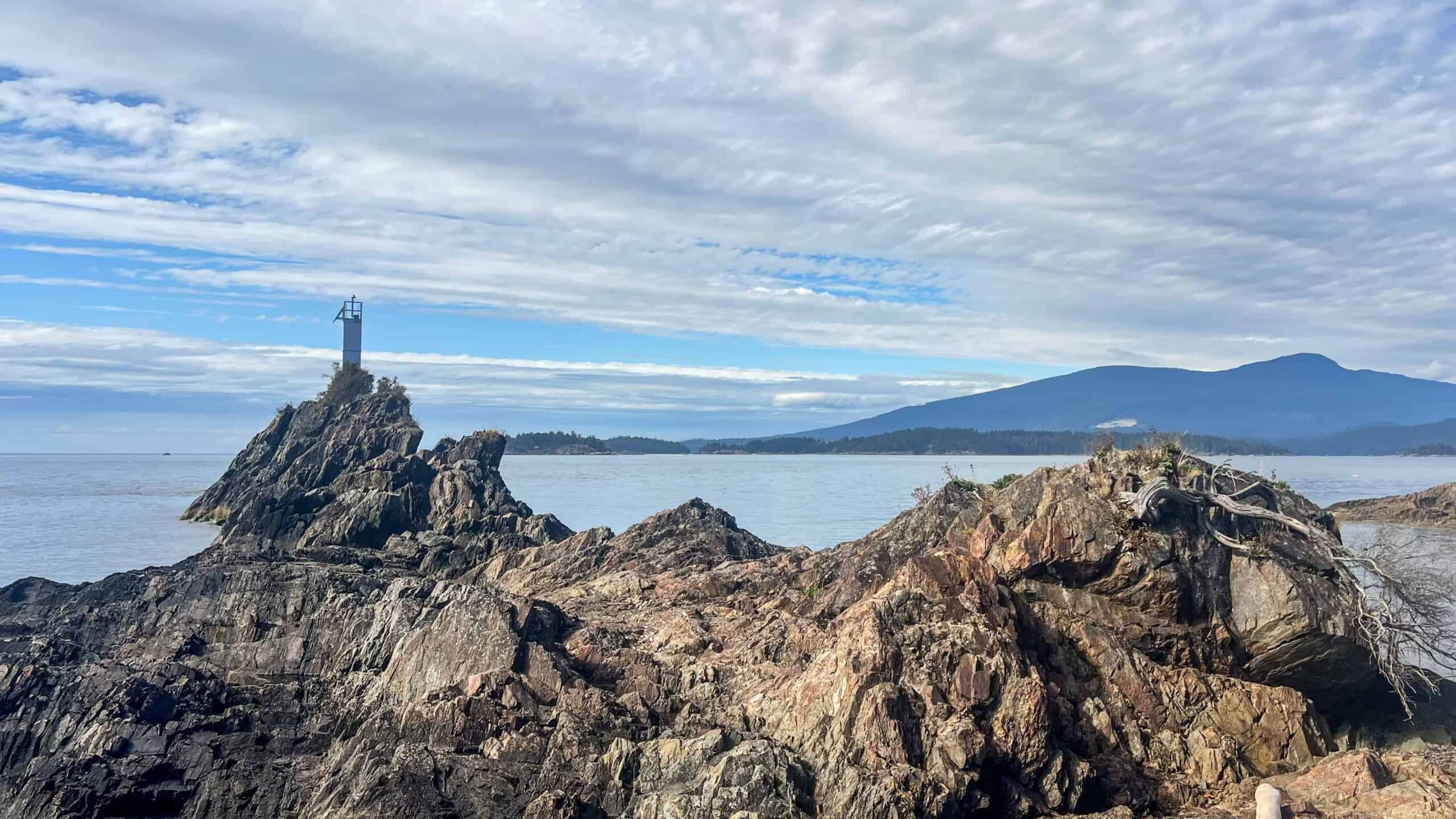
The Cape on Bowen’s Pebbly Beach and the Lighthouse Loop: Trails at the Edge of the World
For many outdoor enthusiasts and luxury seekers, the primary draw to the southwest tip of the island is the Cape Roger Curtis Lighthouse Loop. This world-class trail system offers unparalleled access to a rugged, windswept coastline that feels like the very edge of the continent. It is here that high-end island living is most visible, as the trails weave between exclusive nature estates and the vast, crashing beauty of the Salish Sea.
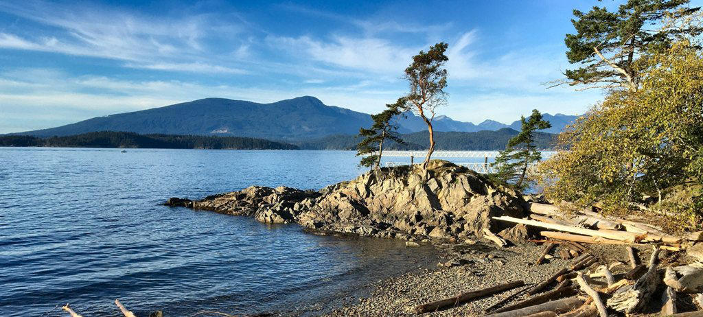
Pebble Beach Seawalk Trail: A 1.5-Mile Coastal Odyssey
The crown jewel of the local trail network is the Pebble Beach Seawalk Trail (often searched as the Roger Curtis Walk). This 1.5-mile (2.4 km) out-and-back trail is widely considered an easy hike on Bowen Island, making it accessible for families, birdwatchers, and photographers alike.
- Trail Difficulty and Logistics: With a gentle 160 ft elevation gain, the trail takes approximately 35–60 minutes to
complete. It is perfectly maintained, featuring a mix of gravel paths and architectural wooden structures.
- Whale Watching on the Whale Trail (The Whale Trail on Bowen Island): This path is part of the larger
B.C. Whale Trail, a series of coastal vantage points. It is common for hikers to spot Orcas (Killer Whales), Humpback whales, sea lions, and harbor seals directly
from the shore, particularly during the early morning or late evening feeding times. The Whale Trail on Bowen Island is definitely a must-experience!
- Birding and Biodiversity: The trail winds through a sensitive dry coastal bluff ecosystem, home to rare Arbutus trees and a diverse array of marine birds.
The Cantilevered Walkway:
Bowen Island’s Most Photographed Sunset Spot
Perhaps the most iconic “Instagrammable” feature of the Cape’s public amenities is the cantilevered walkway. This architectural marvel is pinned directly into the ancient basalt rock face, overhanging the coastal bluffs high above the churning water.
- Front-Row Seats to the Salish Sea: The walkway provides an unobstructed, panoramic view of the Georgia Strait and the Gulf Islands in
the distance.
- Proposal Point: A specific section known to locals as “Proposal Point” at The Cape on Bowen Island has become a romantic landmark where
many couples have gotten engaged against the backdrop of the flaming orange sunsets.
- Sunset Photography: Because the Cape on Bowen Island faces due west, it is arguably the best sunset spot on Bowen Island. The way the light hits the Arbutus bark and reflects off the cantilevered glass and steel is a favorite for professional and amateur photographers.
Pebbly Beach Access: A Hub for Adventure and Relaxation
Located at the terminus of the trail near the automated light station (the Cape Roger Curtis Lighthouse), Pebbly Beach (also known as Roger Curtis Beach) is a sanctuary for those who love the water.
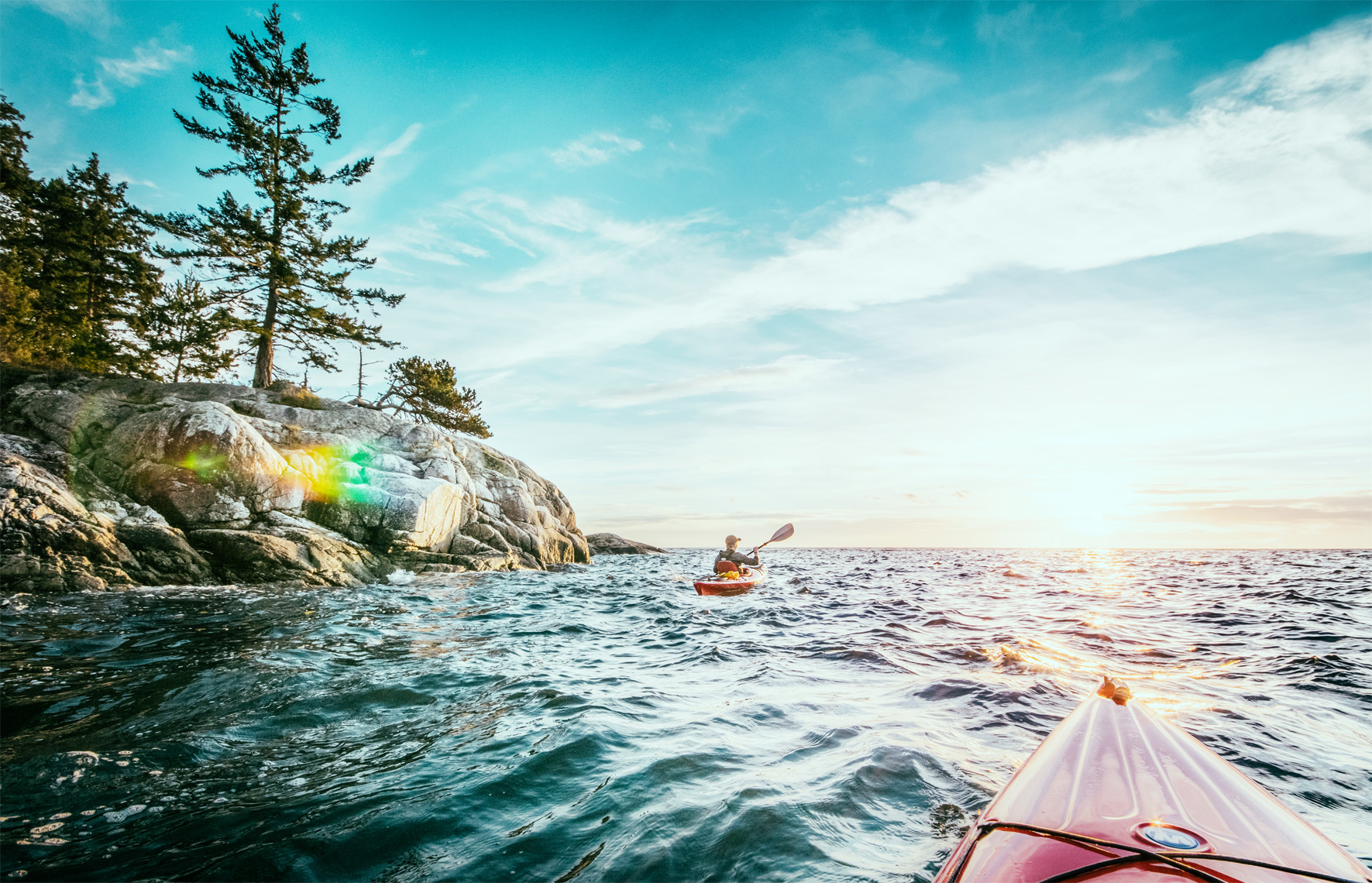
- Kayaking and Paddleboarding: The beach serves as a vital launch point for sea kayaking on Bowen Island. Its southwest exposure makes the waters
here slightly calmer and the air about 3 degrees warmer than the eastern side of the island. Paddlers often use this as a stopping point when circumnavigating the island or exploring
the nearby Pasley Islands.
- Beachcombing and Picnics: The shore is a treasure trove for beachcombers looking for unique basalt rocks and driftwood. There are several
large logs and flat rocks perfect for a seaside picnic while watching the ferry cross in the distance.
- Swimming and Sunbathing: While the water is refreshing, the “Pebbly” nature of the beach means it’s best to bring sturdy water shoes. It remains a popular spot for a “polar bear” dip or a warm afternoon of soaking in the sun.
The Bowen Island Campground Controversy: Why the Cape Roger Curtis Campground Proposal Failed
The most significant chapter in recent island history centers on the failed Bowen Island campground proposal by Metro Vancouver Regional Parks. For years, a heated debate dominated local headlines, pitting regional accessibility against environmental preservation. Today, the “Bowen Island campground” remains one of the most searched terms for the island, though the reality is far different from what was originally planned. Read more about the proposed Cape Roger Curtis Campground on Bowen Island.
The Metro Vancouver Proposal: A Vision for Regional Access
In 2022, Metro Vancouver announced a $40 million purchase of 97 hectares (240 acres) of waterfront land at Cape Roger Curtis. The intent was to create a new Regional Park that would finally provide overnight camping on Bowen Island—a service that has been historically unavailable.
- The Specifics: The Cape Roger Curtis campground proposal included approximately 50 to 100 campsites,
designed primarily for walk-in and bike-in tent camping.
- The Goal: Metro Vancouver aimed to offer “affordable coastal access” to the 2.8 million residents of the mainland, positioning the Cape as a key link in the regional park system.
- Proposed Infrastructure: The Bowen Island camping plan included supervised campsites, pit toilets, and improved trail connectivity to the Cape Roger Curtis Lighthouse Loop.
The Local Response: Why the Community Said “No”
The proposal for the Bowen Island campground at The Cape met with immediate and “overwhelming public opposition” from the Bowen Island Municipality, the Bowen Island Conservancy, and the local community. The opposition was not rooted in “NIMBYism,” but in specific, logistical, and environmental realities of island life.
- Extreme Wildfire Risk: The southwest tip of the island is home to a dry coastal bluff ecosystem. Locals argued that introducing campfires
(or even camp stoves) into this highly flammable Arbutus and Douglas Fir forest during BC’s increasingly severe drought seasons was a recipe for catastrophe down at The Cape on Bowen Island and neighbourhoods surrounding it.
- Ferry Capacity and Infrastructure: The Queen of Capilano ferry is already at maximum capacity during peak season. Residents argued that
adding hundreds of Bowen Island campers weekly would cripple the only transit link for locals and emergency services.
- Ecological Sensitivity: The Bowen Island Conservancy highlighted that the Cape is a biodiversity hotspot. The high-density foot traffic of a campground would threaten the rare flora and fauna that make the Wild Coast Nature Refuge unique.
The 2024 Outcome: The $30.5 Million Community Buy-Back
In a move that made national headlines, the community took matters into its own hands. To prevent the proposed Bowen Island campground from proceeding, a massive fundraising effort was launched.
- The Historic Purchase: In late 2023 and early 2024, the Bowen Island Conservancy—fueled by over $30 million in private donations—negotiated
a deal to buy 65 hectares of the land back from Metro Vancouver.
- The Death of the Campground: As a result of this purchase, the Metro Vancouver Bowen Island campground proposal at the Cape Roger Curtis was officially cancelled.
The land was instead designated as a Nature Reserve under a conservation covenant.
- Current Status: There is no camping permitted at Cape Roger Curtis. The area is now protected in perpetuity for day-use only, ensuring the “untamed luxury” of the silence remains undisturbed.
Coastal Circadian Recovery & The South-West Wellness Loop: From The Cape to Queen Charlotte Heights
While a day spent navigating the windswept bluffs of The Cape on Bowen is deeply restorative, the ultimate “biohack” for a total system reboot is the intentional transition from the wild, south-western coast back to the curated sanctuary of The Barnfield Suites. Located in the prestigious Queen Charlotte Heights, our property serves as the essential recovery anchor for those who spend their days exploring the Cape Roger Curtis Lighthouse Loop and the sun-drenched shores of Pebbly Beach.
The Circadian Sunset Bridge: Sunset at the Cape, Stillness in the Heights
Science in 2026 highlights the critical role of “low-angle sun” exposure in regulating human hormones and mitochondrial health. By witnessing the legendary sunsets from the cantilevered walkway at The Cape, you are initiating a natural circadian rhythm reset . Returning to The Barnfield Suites allows you to “lock in” this hormonal shift. Our suites in the Heights are engineered for absolute darkness and acoustic stillness, facilitating a level of deep sleep optimization that complements the raw energy of the Salish Sea.
The “Wild Coast” Thermal Reset: Cedarwood Elements
Ocean immersion at Pebbly Beach or a brisk hike along the Whale Trail is a powerful form of hydrotherapy, but the true metabolic benefit is found in the strategic “re-warming” process. Our Cedarwood Elements sanctuary provides the perfect thermal bridge for those returning from the Cape’s rugged terrain.
- The Contrast Protocol: After absorbing the salt air and coastal wind, our private cedar barrel sauna and professional-grade
cold plunge (utilizing the Søberg Principle) trigger lymphatic drainage and a profound nervous system reset.
- Mineral Recovery: The intense heat helps the body process the mineral absorption from your time at the shore, completing a high-performance metabolic detox that transition you from “adventure mode” to “recovery mode.”
High-Performance “Slow Living” Infrastructure
For travelers who appreciate the “Barnfield” aesthetic of the island’s most exclusive 10-acre nature estates, The Barnfield Suites in Queen Charlotte Heights offers the corresponding luxury infrastructure for an overnight stay.
- Gourmet Wellness: Rather than rushing back to the ferry, our guests use our full gourmet kitchens to prepare organic, mineral-rich meals,
extending the peacefulness of the Cape into a multi-day retreat.
- Intentional Design: Our suites reflect the same commitment to organic modernism found in the Cape’s legacy homes, providing a consistent aesthetic experience for high-net-worth wellness seekers.
Botanical Restoration for the Coastal Traveler
To counteract the drying effects of the salt spray and Pacific winds encountered at the Roger Curtis Lighthouse , we exclusively feature Sangre de Fruta organic botanicals. These small-batch, plant-based products provide essential skin health recovery, ensuring that your journey to the island’s southwest tip results in a physical glow that matches your newfound mental clarity.
Frequently Asked Questions:
Cape Roger Curtis, Camping, and Bowen Island Luxury
1. Can you camp on Bowen Island?
Currently, there are no public or private campgrounds on Bowen Island. The island is strictly a day-trip destination for hikers and beachgoers, or a place for overnight stays in
licensed accommodations like The Barnfield Suites.
2. What happened to the Metro Vancouver campground proposal?
The proposed Bowen Island campground was officially cancelled in late 2023. Following significant public opposition regarding wildfire risk and infrastructure strain, the
Bowen Island Conservancy raised over $30 million to buy the land and turn it into a protected Nature Reserve.
3. Is there any RV camping or “van life” parking on Bowen Island?
No. There are no dedicated RV parks or overnight parking zones for campers on the island. Sleeping in vehicles on public roads or at trailheads like Cape Roger Curtis is strictly
prohibited and enforced by local bylaws.
4. Why was the Cape Roger Curtis campground proposal so controversial?
The controversy centered on three main issues: the high wildfire risk in the dry coastal bluff ecosystem, the lack of ferry capacity on
the Queen of Capilano, and the environmental impact on the sensitive Arbutus groves.
5. How long is the Cape Roger Curtis Lighthouse Loop?
The Cape Roger Curtis Lighthouse Loop (Pebble Beach Seawalk) is an easy 2.4 km (1.5 mile) out-and-back trail. It typically takes 45 to 60 minutes to
complete at a leisurely pace.
6. Where is the best place to see sunsets on Bowen Island?
The cantilevered walkway on the Cape Roger Curtis Seawalk is widely considered the #1 sunset spot on Bowen Island, offering panoramic
views of the Salish Sea and the Gulf Islands.
7. Can you see Orcas from the shore at Cape Roger Curtis?
Yes. Cape Roger Curtis is a designated site on the B.C. Whale Trail. It is a premier location for spotting Orcas (Killer Whales), Humpbacks,
and sea lions from the rocky bluffs.
8. Who developed the luxury estates at The Cape on Bowen?
The 32 ten-acre nature estates were developed by The Cape on Bowen Community Development Ltd., led by developers Don Ho and
Edwin Lee.
9. Is Pebbly Beach (Roger Curtis Beach) dog-friendly?
Yes, but dogs must remain on a leash. This is to protect the sensitive coastal forest habitat and nesting birds in the area.
10. What is the “Barnfield” aesthetic in Bowen Island real estate?
The “Barnfield” aesthetic refers to a “Quiet Luxury” design philosophy—using natural materials like cedar and stone to create a high-end, modern sanctuary that blends seamlessly
into the Pacific Northwest wilderness.
11. Is Bowen Island part of a UNESCO site?
Yes. Bowen Island is located within the Howe Sound (Átl’ka7tsem) UNESCO Biosphere Region, which recognizes the area’s global ecological significance.
12. How far is the Cape from the Snug Cove ferry terminal?
It is approximately a 15-minute drive (9 km) from Snug Cove. Note that there is no direct public bus to the Cape; a car or e-bike is required.
13. Are there beach fires allowed at Pebbly Beach?
No. Beach fires are strictly prohibited year-round on all parts of Bowen Island due to the extreme risk of wildfire.
14. What is the Bowen Island Conservancy?
The Bowen Island Conservancy is a local land trust that successfully led the $30.5 million acquisition of the Cape Roger Curtis land to prevent development and camping.
15. Is the Cape Roger Curtis Lighthouse open to the public?
The lighthouse is a small, automated navigation light. While you can hike right up to it for photos, the structure itself is closed to the public.
16. Where can I find camping near Horseshoe Bay now that the Bowen site is cancelled?
Alternative camping can be found at Porteau Cove Provincial Park or Alice Lake on the mainland, both located north of Horseshoe
Bay on the Sea-to-Sky Highway.
17. What is “Quiet Luxury” on Bowen Island?
It is a shift toward understated, high-end travel experiences that prioritize privacy, wellness, and environmental connection over flashy displays of wealth.
18. Does The Barnfield Suites offer camping?
No. The Barnfield Suites is a luxury retreat in Queen Charlotte Heights. We offer refined indoor suites and a private wellness circuit
called Cedarwood Elements.
19. What is the Cedarwood Elements wellness circuit?
It is a private contrast therapy experience including a custom-built cedar barrel sauna and a professional cold plunge,
designed for the “Søberg Principle” of metabolic and nervous system health.
20. Can I launch a kayak from Pebbly Beach?
Yes. Pebbly Beach is a popular kayak launch point for exploring the southwest coast and the nearby Pasley Islands.
21. Is the Cape Roger Curtis trail wheelchair accessible?
The Pebble Beach Seawalk is relatively level and made of packed gravel, making it accessible for rugged strollers and some wheelchairs, though some sections are narrower than others.
22. Are there bears on Bowen Island?
Black bears are occasionally spotted on the island, but they are not permanent residents. Most wildlife sightings include black-tailed deer, eagles, and marine life.
23. Is there Wi-Fi at Cape Roger Curtis?
Cell service is spotty at the Cape, making it an ideal location for a digital detox. However, the luxury estates in the area are equipped with high-speed fiber optics.
24. What is the Fairy Fen Nature Reserve?
Located near the Cape, Fairy Fen is a unique wetland ecosystem and a popular destination for hikers looking for a more forested, inland trail experience.
25. Why is the water at Pebbly Beach warmer?
The beach’s southwest exposure allows it to absorb more sunlight throughout the day, often making the air and shallow water a few degrees warmer than the north side of the island.
26. Can you host weddings at Cape Roger Curtis?
The trails and beaches are public day-use areas. Large organized events like weddings require a special event permit from the Bowen Island Municipality.
27. Do I need to book a ferry to get to Bowen Island?
You cannot book a reservation for the Horseshoe Bay to Snug Cove ferry. It is first-come, first-served. It is recommended to arrive 30–45 minutes early.
28. How do I experience the “Barnfield” lifestyle if I’m not a resident?
By staying at The Barnfield Suites in Queen Charlotte Heights, you can experience the architecture, privacy, and wellness-focused lifestyle that defines the island’s most exclusive
estates.
29. What was the exact location of the proposed Bowen Island campground?
The proposed Bowen Island campground was slated for 97 hectares (240 acres) of waterfront land at Cape Roger Curtis, located on
the southwestern tip of the island. The site included the rugged coastal bluffs and Arbutus groves near Pebbly Beach.
30. Why did the Bowen Island Municipality oppose the Metro Vancouver regional park?
The Bowen Island Municipality issued several formal concerns, primarily focusing on the lack of infrastructure to support overnight
visitors. The primary sticking points were the capacity of the Queen of Capilano ferry, the absence of public transportation to Cape Roger Curtis,
and the severe wildfire risk to the community.
31. How much did Metro Vancouver pay for the Cape Roger Curtis land?
In 2022, Metro Vancouver purchased the 97-hectare parcel for $40 million with the intent of creating a regional park. However,
after the proposal was rejected locally, the Bowen Island Conservancy negotiated a deal to buy the majority of that land back for $30.5 million to
preserve it as a Nature Reserve.
32. Was walk-in camping ever allowed at Cape Roger Curtis?
No. While walk-in and bike-in camping were the primary features of the Metro Vancouver proposal, the project never reached the construction
phase. The land remains for day-use only, and pitching a tent or staying overnight is strictly prohibited.
33. What is the status of the “Wild Coast Nature Refuge” on Bowen Island?
The Wild Coast Nature Refuge is the new name for the land formerly intended for the campground. Thanks to the $30.5 million community fundraising effort,
this land is now protected in perpetuity. It is managed by the Bowen Island Conservancy with a mandate of “conservation first,” meaning no camping will ever be permitted.
34. Are there any alternative places to camp near Bowen Island?
Since camping on Bowen Island is unavailable, visitors are directed to Porteau Cove Provincial Park (20 minutes north of Horseshoe
Bay) or Halkett Bay Marine Provincial Park on Gambier Island, which is accessible only by boat.
35. Who were the main groups against the Bowen Island campground?
The opposition was led by the Bowen Island Conservancy, the Cape Roger Curtis Trust, and a large coalition of local residents. They argued
that the Bowen Island OCP (Official Community Plan) did not support the high-density nature of a 100-site regional campground.
36. Did the campground proposal include RV hookups?
No. The proposed Cape Roger Curtis park specifically excluded RVs and large campers due to the narrow, winding nature of Whitesails Drive and
Roger Curtis Lane, as well as the limited ferry deck space for oversized vehicles.
37. Will there be any overnight accommodation at the Cape in the future?
The only overnight stays permitted in the Cape area are within the 32 private 10-acre estates. For public visitors, the closest luxury accommodations are located across the island at
The Barnfield Suites in Queen Charlotte Heights.
38. How does the cancellation of the campground affect the Lighthouse Loop?
The Cape Roger Curtis Lighthouse Loop remains open for public day-use. The cancellation of the campground actually ensures that the trail stays quieter and the “untamed luxury”
of the Salish Sea views remains undisturbed by high-volume foot traffic.